Offshore Wind Energy Demonstrator
The Offshore Wind Energy (OWE) Demonstrator is an interactive Dashboard. The Demonstrator has communication purposes with the aim to inform stakeholders on the current conditions of the 19 High Potential Zones for OWE development (in spanish named ZAP – Zonas de Alto Potencial) recently defined in the first Maritime Spatial Plan of Spain (POEM – Plan de Ordenación del Espacio Marítimo; RD 150/2023). The interactive map allows to explore how the OWE Sites perform under different spatial indicators and compares OWE sites across planning Demarcations in the Atlantic and Mediterranean, such as distance from shore, collision risk, overlay with existing protected areas etc…This test Demonstrator is meant as a prove of concept and will be regularly updated as new information gets available along with the other Dashboards that will be developed during the Project implementation.
Data sources, methods applied for indicator construction and literature resources
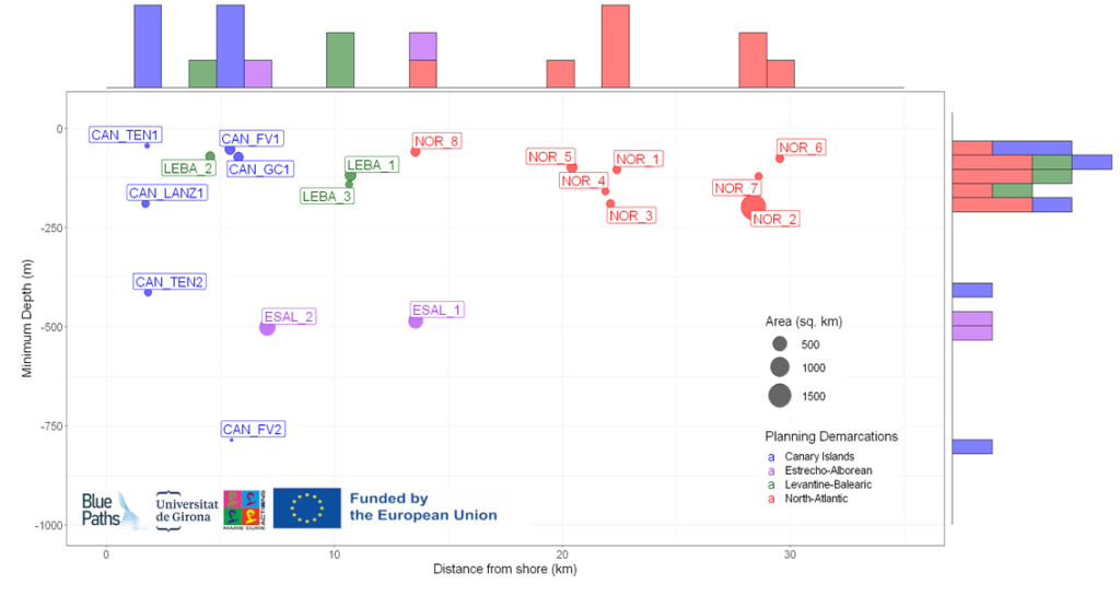
The Figure below provides an overview of the current OWE Landscape as a function of the sq. km of the OWE array, the minimum distance from shore (in km) and the minimum water depth (in meters) inside the OWE array. The aim of the graph is to provide a graphical understanding of where the HPA OWE Sites are located according to the different POEM Planning Demarcations.
 Figure 1. OWE Landscape of Spain. Note: The Planning Demarcation South-Atlantic does not have any HPA OWE Sites.
The OWE area indicator describes the area in sq km covered by each of the 19 High Potential OWE Sites of the Spanish Maritime Spatial Plan.
RESOURCES & FURTHER READING:
- POEM, 2023. PLANES DE ORDENACIÓN DEL ESPACIO MARÍTIMO. RESUMEN EJECUTIVO. Web: https://www.miteco.gob.es/es/costas/temas/proteccion-medio-marino/4resumenejecutivopoem_tcm30-552786.pdf. February 2023.
- EMODNet, 2023. Bathymetry. Web: https://emodnet.ec.europa.eu/geoviewer/.
- MITECO, 2023. Roadmap offshore wind and marine energy in Spain. Web: https://www.miteco.gob.es/es/ministerio/planes-estrategias/desarrollo-eolica-marina-energias/enhreolicamarina-pdf_accesible_tcm30-538999.pdf.
RESOURCES & FURTHER READING:
- Manchado, C., Gomez-Jauregui, V., Lizcano, P.E., Iglesias, A., Galvez, A., Otero, C., 2019. Wind farm repowering guided by visual impact criteria. Renewable Energy 135, 197–207. https://doi.org/10.1016/j.renene.2018.12.007.
- Filgueira-Vizoso, A., et al., 2021. How important are ports for the offshore wind industry?: the case of Spain. REPQJ 19, 121–125. https://doi.org/10.24084/repqj19.232.
- Gkeka-Serpetsidaki, P., Papadopoulos, S., Tsoutsos, T., 2022. Assessment of the visual impact of offshore wind farms. Renewable Energy 190, 358–370. https://doi.org/10.1016/j.renene.2022.03.091.
This indicator describes the Average Wind Speed in meters/second at 200 meter height.
RESOURCES & FURTHER READINGS:
The indicator describes the portion of OWE Sites (in percentage) overlapping with Priority Use Areas (ZUP – Zonas de Uso Prioritario) for Protection of Biodiversity, reflecting the actual areas of marine protection. For instance a score of 100% indicates that the entire OWE Sites is located inside a marine protected area. In the actual state the indicator does not include the overlap for High Potential Areas areas for conservation of biodiversity (ZAP) that are available on the Visor de Informacion Geografica Marina of the Spanish Ministry for The Ecological Transition and Demografic Challenge (MITECO).
SOURCES & FURTHER READING:
The Collision Risk Index (CRI) describes the intensity of shipping traffic (including tankers, cargo, passenger and sailing) within a radius of 0.5nm – 3.5nm (926m – 6482m) this is deemed tolerable if the risk is being reduced to as low as reasonably practicable (ALARP principle). The CRI is applied using EMODNet Human Activity datasets on shipping traffic and aims to compare how different potential OWE Sites would interact with shipping traffic activities.
RESOURCES & FURTHER READING:
- MSP-Platform, 2018
- Fetissov, M., et al., 2018. Towards navigational safety of ecosystem based Maritime Spatial Planning solutions. SHS Web of Conferences. 58. 01008. 10.1051/shsconf/20185801008.
This indicator describes the potential of the OWE Site to be combined with other Blue Economy activities such Aquaculture. A horizontal and multi-sectorial objective of the POEM is the co-existance and promotion of positive synergies among Blue Economy sectors (POEM, 2023). The index was defined as a function of i) level of commercial specialization of the coastal province to aquaculture development was defined by the number of companies active in the finfish, mussel and algae sector; ii) the level of specialization of coastal regions to the OWE sector was calculated by the number of companies in OWE in Spain (Telsnig et al., 2019) and the iii) distance from ports and logistics which is perceived as fundamental constrain in the aquaculture and OWE sector (Riclet et al., 2022 Filgueira-Vizoso et al., 2021). In Spain, several studies and Research Projects promote the Multi-Use of OWE with Aquaculture (Abramic et al., 2023; Weiss et al., 2018; AquaWind Project, 2023; )
RESOURCES & FURTHER READING:
- EMODnet Human Activities, 2023
- POEM, 2023. PLANES DE ORDENACIÓN DEL ESPACIO MARÍTIMO. Web: https://www.miteco.gob.es/es/costas/temas/proteccion-medio-marino/4resumenejecutivopoem_tcm30-552786.pdf. February 2023.
- Telsnig, T. and Vazquez Hernandez, C., Wind Energy: Technology Market Report, EUR 29922 EN, Publications Office of the European Union, Luxembourg, 2019, ISBN 978-92-76-12569-3, doi:10.2760/223306, JRC118314.
- Riclet et al., 2023. Access to space and water for marine aquaculture. ISBN 978-92-95225-63-3 doi: 10.2926/719654.
- Filgueira-Vizoso, A., et al., 2021. How important are ports for the offshore wind industry?: the case of Spain. REPQJ 19, 121–125. https://doi.org/10.24084/repqj19.232
Examples of Ocean Multi-Use/Co-location studies in Spain
- Weiss, C.V.C., et al., 2018. Co-location opportunities for renewable energies and aquaculture facilities in the Canary Archipelago. Ocean & Coastal Management, Maritime Spatial Planning, Ecosystem Approach and Supporting Information Systems (MapSIS 2017) 166, 62–71. https://doi.org/10.1016/j.ocecoaman.2018.05.006.
- Abramic, A., et al., 2021. Introducing offshore wind energy in the sea space: Canary Islands case study developed under Maritime Spatial Planning principles. Renewable and Sustainable Energy Reviews 145, 111119. https://doi.org/10.1016/j.rser.2021.111119.
-
Ramos, S., Díaz, H., Guedes Soares C., 2022. Potential opportunities of multi-use blue economy concepts in Europe. Guedes Soares, C. & Santos T. A., (Eds.). Developments in Maritime Technology and Engineering London, UK: Taylor and Francis, 2022. ISBN: 9781003320289
- AquaWind 2023. Web: https://aquawind.eu/.
